Britain at Low Tide: S2 E4 Severn Estuary

I love the River Severn, but I tend to stay way upstream, as it wends its way through Shropshire. Canoeing down under Ironbridge and over the Jackfield Rapids has to be one of my favourite things.

The Severn as we see it in this episode of Britain at Low Tide is a different beast altogether. Treacherous, changeable, fast and swirling. Hard to navigate, and hard to cross. But intriguingly, the challenge of crossing this natural barrier appears to have brought communities on each bank of the river closer together, rather than driving them apart. Even today, you can hear people on the Wye side of the river talk about ‘Forest Folk’ and ‘River Folk’; kinship with the water runs deep.

I cannot overstate how dangerous this stretch of the Severn is. The tides rush in. People can, and do, get caught out and die. To get permission to film, we had to have a hovercraft on standby to rescue us, just in case.

We also had to fortune to be guided by Frank Larkham, local skipper (and one of the few remaining people with the knowledge to pilot up river beyond Aust) and owner of the Wastdale and Arkendale wrecks. His knowledge of the tides kept us safe getting to and from these boats. Even so, it was tense. Please, please don’t be foolhardy and venture out into the mud yourself unless you know what you are doing, and take all the necessary precautions (if you don’t know what these are: DON’T GO). AND CHECK THE TIDES.

You can, however, continue to explore the stories in this episode from the safety of your armchair by following the links below

If you want to get involved with local archaeology safely, get in touch with the CITiZAN team, and find out what opportunities and events there are in your area: https://citizan.org.uk/get-involved/


If you want to know more about the archaeology of the tidal Severn, the Severn Estuary and Levels Research Committee is the place to visit — as ever, we could only scrape the surface of the fascinating history and prehistory of this region: http://www.selrc.org.uk/

This episode is really all about crossing the River Severn, and this blogpost by CITiZAN’s Alex Bellisario covers much of the history of the ingenious ways people have done — or attempted to do — just that: https://www.citizan.org.uk/blog/2017/Apr/22/crossing-the-severn-through-the-ages/

And Chris Witts, who shared his memories of the Severn Bridge Disaster with us (see WASTDALE AND ARKENDALE/SEVERN BRIDGE DISASTER below) wrote a whole book called The Severn Estuary Crossings

AUST TO BEACHLEY FERRY

This video has fabulous vintage footage from the Huntely Film Archive of the Aust-Beachly Ferry in the 1930s:


SUB-AQUEOUS TUNNEL

I love tunnels, especially lost or abandoned ones, so I was gutted I didn’t get to do this story. Lucky Oliver!


WASTDALE AND ARKENDALE/SEVERN BRIDGE DISASTER

Chris Witts has his own blog, and he tells the story of the Severn Bridge Disaster there in much greater detail than we could possibly do in the programme. I recommend reading it: http://www.severntales.co.uk/severn-bridge-disaster.html

Chris has also written a book all about Severn crossings, called

ST TWROG’S CHAPEL*

St Twrogs really is a bit of a mystery, and I have struggled to find anything accessible to link to for further reading. But:


*With apologies for pronunciation. I think I should have been pronounced more like ‘Tur-rogs’, but consistency (and a lack of confidence in my own opinion at the time…) required me to fall in with Trogs…  


Britain at Low Tide: S2, E3 Clyde

“Glasgow made the Clyde, and the Clyde made Glasgow”

For the first time, we head north of the border to Scotland! And whilst Gus, Oliver, and Charlotte come along for the ride, our expert guides are Tom, Jo, Ellie and Tanya from SCAPE, whose Scotland’s Coastal Heritage at Risk Project (SCHARP) was the inspiration for CITiZAN.

This week it all gets a bit muddy, as we explore the banks of the tidal River Clyde. This episode blew my mind, as it seems totally ridiculous that a river that built and launched some of the world’s largest ships could be WADED ACROSS just a couple of hundred years ago.

As ever, there was so much we couldn’t fit in to a Channel 4 hour. So here are some links to help you delve a little deeper into the fascinating archaeology and history of the Clyde.

After a weekend of for Crufts, Britain at Low Tide is back **17TH MARCH, 8PM, CHANNEL 4** where we will be investigating the Severn, and those who have braved its tricksy, dangerous crossings, from medieval hermits to Bob Dylan…


NEWSHOT SHIP GRAVEYARD

img_6363

The mud isn’t the only obstacle to observing intertidal archaeology…

This is the home of the MUD PUNTS (impossible to say this without a twinkle, for some reason…), the SCHOONERS, and THE DIVING BELL BARGE. A veritable treasure trove, capturing the history of the deepening of the Clyde, and the growth of Glasgow as a city.


DUMBUCK CRANNOG

Oh, how I love this Crannog. And we didn’t even get to go into the fascinating, tragi-comical history of the site, full of fakes and ‘queer objects’. Trust me, it’s worth looking into:

  • Start by reading this illustrated, accessible, and un-put-downable introdcution to the site by Alex Hale (who we met in the programme) and Rob Sands: Controversy on the Clyde, Archaeologists, Fakes and Forgers (out of print, but you can still find copies for sale online)
  • or take a look at the site summary, complete with fabulous images: https://canmore.org.uk/site/43402/dumbuck
  • And here is a nice paper on dating the Clyde Crannogs (there are at least FOUR!), by Alex and colleagues, with some context and background info: http://eprints.gla.ac.uk/148822/1/148822.pdf [pdf]


TIMBER PONDS (AND LORDS)

img_6360

BALT crew filming at the Timber Ponds. This was before the tide started to come in, and I had to do my ‘pensive wading’ shots.

The Timber Lords were the money and power behind the early growth of Glasgow. The sheer extent of the timber ponds,even just the stumps in the mud that remain, are testament to this wealth. What we didn’t touch on, and what I wish we had, was the dark side to this trade wealth: slavery.


LANG DYKE

The Lang Dyke was the 18th Century engineering solution to the Timber Lords’ problem of not being able to get their ships close to the city.

img_6391

Thanks to Tanya T-dog Venture for this fine Lang Dyke meme.

Britain at Low Tide: S2, E2 Dorset

A bit of extra info, with links, in case you want to delve a bit deeper into the stories featured in Episode Two of Britain at Low Tide, Series Two.

This particular episode was fun, but also very moving to film. It’s a funny feeling, because from the safe distance of 2018, it is all to easy to get caught up in the excitiment of a Girls Own adventure — I got to ride in a tank! And go out on a boat! And explore beneath the waves with a remotely operated submersible!

And then it hits you: the reality of war. People died. And their loved ones didn’t know why, or when, or where. FOR OVER FIFTY YEARS.

Thankfully, people like John Pearson exist. He’s not just a tank enthusiast, though I am glad he is that too (thanks for the tank ride, John!): he was he was responsible for placing the plaque at Fort Henry commemorating the six men who died in Exercise Smash. For the first time, family members like Joan Brunt, the widow of Arthur Parks, had a memorial for their loved ones where they could mourn their passing.

So lets just take a moment to remember those who died on the 4th April 1944:

  • Sergeant V. Hartley
  • Corporal Arthur J. Park
  • Corporal V. N. Townson
  • Trooper A. Kirkby
  • Trooper E. G. Petty
  • Lieutenant C. R. Gould

Just six names amongst the tens of millions of people who died worldwide in the second world war. But worth remembering nonetheless.

~

Next week we are across the border on the River Clyde, where we lark around in the mud investigating how a river as ridiculously shallow as the Clyde ended up becoming the shipyard for some of the world’s largest ships… and get scorched uncovering the secrets of a mysterious crannog — 8pm, 3rd March, Channel 4.

And don’t forget, if you want to get involved in coastal archaeology CITiZAN have loads of opportunities: https://citizan.org.uk/get-involved


EXERCISE SMASH

Valentine Duplex Drive tanks weren’t actually used in D-Day. Instead, by the time the 6th June 1944 came around, enough of the bigger and better (it didn’t have to have it’s gun turret spun around in the wrong direction while afloat..) Sherman Tanks had been modified to duplex drive, with the characteristic canvas skirts. Valentines continued to be used for training, and also saw active service in Italy 1945.

IRON AGE POOLE

BROWNSEA ISLAND CLAY WORKS

img_6453

CITiZAN volunteers at work recording the Sea Plane Lighter in the mud of Poole Harbour

SEA PLANE LIGHTER

Britain at Low Tide: S2, E1 East Sussex

Some handy links and info if you want to delve a bit deeper into the stories featured in Episode One of Britain at Low Tide, Series Two.

If you missed Episode One, East Sussex, catch up here: http://www.channel4.com/programmes/britain-at-low-tide/on-demand/66195-002

Next week we are in sunny Dorset, where we investigate some sunken tanks that helped change the military strategy for D-Day (no biggy), and an enigmatic and ancient structure submerged in Poole Harbour — 8pm, 24th February, Channel 4.

And don’t forget, if you want to get involved in coastal archaeology CITiZAN have loads of opportunities: https://citizan.org.uk/get-involved/


SMEATON’S HARBOUR

THE AMSTERDAM

****QUICKSAND CLAXON!! WARNING: THIS SITE IS DANGEROUS****

PETT LEVEL

  • Here is the CITiZAN report on their work at Pett Level: https://citizan.org.uk/resources/key-zones/south-east/pett-level-east-sussex/
  • And here are some really interesting papers on the ancient environment at Pett Level, and the complex task of reconstructing and understanding sea level change:
    • Long, A. J. and Waller, M. P. and Stupples, P. (2006) ‘Driving mechanisms of coastal change : peat compaction and the destruction of late Holocene coastal wetlands.’, Marine geology., 225 (1-4). pp. 63-84. [pdf]
    • Waller et al. (1998), Flandrian Sedimentation and Palaeoenvironments in Pett Level, the Brede and Lower Rother Valleys and Walland Marsh [pdf]
  • And a nice summary of the local geology and landscape of the coastline between Hastings and Pett: Robinson and Wilson, THE HIGH WEALD COAST FROM HASTINGS TO PETT: Classic Landforms of The Weald, Landform Guide No. 4 pp 39 – 43 [pdf]
img_6302

Medieval ship graffiti in the Church of St Thomas the Martyr, Winchelsea

SHIP GRAFFITI

Gus and I were shown the Ship Graffiti in St Thomas’, Winchelsea by Natalie Cohen of the National Trust/Museum of London. Winchelsea is a remarkable town, and it’s history — and how fundamental ships were to it — is something we that we just didn’t have time to do justice to.

But if you want to know more, I heartily recommend reading Thomas Dhoop’s PhD thesis Shaped by Ships and Storms: A Maritime Archaeology of Medieval Winchelsea [Volume 1 and Volume 2]

BRONZE AGE SHAFT


Britain at Low Tide is BACK!

Britain at Low Tide is back for a new series! Six whole episodes, airing over six weeks, of archaeological and historical goodness (and the odd bit of geology I managed to squeeze in under the radar), starting 8pm, Saturday 17th February, on Channel 4.  And it’s all bathed in glorious sunshine (well, mostly…) to banish the damp, drear days of never-ending winter.

This series, Gustav, Charlotte, Oliver and I are visiting the shorelines of East Sussex (Episode 1, 17th Feb), Dorset (Episode 2, 24th Feb), The Clyde (Episode 3, 3rd March), The Severn (Episode 4, 10th March), East Yorkshire (Episode 5, 17th March), and Fife (Episode 6, 24th March).

We have shipwrecks, lost harbours, sunken tanks, enigmatic structures, incredible feats of Bronze Age engineering, crannogs, beacons, Bob Dylan, medieval graffiti, Pictish cave art, ancient forests, ferries, trains, and seaplanes (and their lighters). Do watch!

Get involved…

As with the first series, Britain at Low Tide is all about how YOU can help to preserve our coastal heritage. As well as continuing to work with CITiZAN (download their archaeology app here), we teamed up with Scottish public archaeology initiative SCHARP. Both these projects are doing great work recording, investigating and — where possible — preserving the archaeology of our foreshore. And if you’ve ever wanted to try your hand at archaeology, both SCHARP and CITiZAN have loads of opportunities to get your boots mucky…

Scotland’s Lost Asteroid–One Year On, and NW Highlands Geopark Needs Your Help

Walking Through Time is being repeated! Episode 1, Scotland’s Lost Asteroid, is being broadcast again at 8pm, Saturday 29th April, Channel 4.

It is almost a year since we were filming in that incredibly beautiful part of Britain, and as I was just up there for a holiday I can report that the scenery is just as stunning, the people as welcoming, and the geology as awe-inspiring as it was when we filmed.

But things have changed. First the good news:

Dr Mike Simms has been continuing his research into the impact crater, and tells me,  “there are hints that [it] might be much bigger than first thought”, which is pretty exciting — keep your eyes peeled for a publication in the next few months! 

And after seeing our programme, the town of Lairg is putting on a special exhibition all about the impact crater. Local artist Emma Armstrong has been working with Lairg Primary School, and they produced three wonderful info boards for the exhibition (more on this below).

And now for the bad news.

The Northwest Highlands Geopark, which covers the entire area we filmed in — one of the most geologically important areas IN THE WORLD — is at risk of losing its UNESCO status. It needs funds to bridge gaps in its staffing budget, to enable people like Dr Laura Hamlet who helped us out no end with filming (and was brilliant on screen — watch her, you’ll see!) to continue their excellent work in engaging locals and visitors alike with the geology that underpins their lives.

It is shocking that their core funding, when they do so much for the region and the nation, is so precarious.

The NW Highlands Geopark are crowdfunding £70,000 to keep their work going throughout 2017. Please, please consider making a donation if you can. It is really easy to do — just follow this link, and spread the word: Love the Geopark Crowdfunding page

img_2896

The epic landscape of the Northwest Highlands Geopark (c) Adrian Glover

But back to the good news.

Lairg has fully embraced its new claim to fame as the site of Britain’s only terrestrial asteroid impact crater, and next week — quite by coincidence — the village is putting on an exhibition at the Ferrycroft Visitor Centre all about the asteroid, and the unit for the impact crater.

Local artist Emma Armstrong worked with pupils from Lairg Primary School to produce three wonderful information panels that will form the centrepiece of the exhibition, before moving to their permanent home as boards along the village trail. Emma pulled in Mike Simms directly to help her and the students get the science right. She told me:

“I went into the school and we spent a day researching asteroid and meteorite strikes, we did rhyming words and phrases to use on the boards, a list of facts and an art session trying to describe the intensity and impact of the strike.” 

I am dead chuffed that our programme has really resonated with the communities that we filmed in. It is exactly the *cough* impact that I hoped for. Yes, big viewing figures are great and all that, but touching peoples’ lives directly in this way is so much better.

Mike Simms feels the same, I know. He writes, “I’ve written loads of papers over the years but none have really made any difference (or even been noticed by) ordinary people in the street. But for once I (or rather we – because without your programme I still think it would have gone un-noticed) have made a genuine difference to a small and rather remote rural community.”

Cockles of my heart suitably warmed.


So to bring this back to the Geopark, and why it is important. Telly is all well and good as a one off, but the work that Laura Hamlet and the rest of the NW Highlands Geopark staff do is important *every day* on the ground. They devise tourist trails, lead tours, talk with school children, and in doing so they enrich the lives and experiences of so many people. Landscape, and the geology which underpins it, is so much more than just a pretty backdrop fro a holiday snap (though that is very nice). It informs how people live their lives, and understanding it gives us a deeper appreciation of the world we live in.

Please help: donate if you can, and even if you can’t help spread the word. Use the #lovethegeopark hashtag on Twitter and Facebook, and share the link to the crowdfunder wherever you can.


Raising Horizons — TrowelBlazers needs your help

TrowelBlazers has teamed up with photographer Leonora Saunders and Prospect Union on a really exciting project. Fourteen modern day pioneers, dressed as their historical counterparts, photographed for an all-new exhibition at the Geological Society in February 2017.

It’s going to look amazing, it’s going to be fun, but –most importantly– it’s going to highlight women working in the Geosciences, and the challenges they face(d), both today and in the past.

But we need your help to make it happen. We need to raise £10,000 (update: £2.5k raised so far!). And if we can raise more, we will be able to take the exhibition on tour, visit schools, and do all sorts of extra awesome stuff.

Watch the video (complete with the Tiny TrowelBlazers).

Read our Guardian on line article: We Must Highlight These TrowelBLazers

Then, if you can, please donate here: https://www.indiegogo.com/projects/raising-horizons-200-years-of-trowelblazing-women-photography–2#/

If you can’t afford to donate yourself, please do still get involved to help us make a difference: share the link to our crowdfunder, and our blogposts on trowelblazers.com to read the word about the importance of women’s contributions to archaeology, geology, and palaeontology.

Walking Through Time: Jurassic Coast — the reading list

There is so much packed into episode 3 of Walking Through Time, that this reading list only does the science and history partial justice. But here goes anyway…

[Where I can I’ve included links to open access of free to access papers, or popular summaries]

Ocean Anoxia

[Strictly speaking, the anoxia in the seas at Kimmeridge is only local scale, rather than ocean anoxia]

Anoxia *generally* seems to happen when something (eg increased nutrients to the sea waters) cause a sudden increase in the amount of algae, which then use up most or all of the oxygen in the surrounding waters. These algae then also die and sink to the seafloor in a kind of sludge, which is the source of the oil in the shale beds. Other factors can contribute, though. For example, warm water can hold less oxygen, so warmer climates are more susceptible to anoxic events. And warm climates also tend to have more weathering on land (increased rainfall, and run-off), meaning more nutrients enter the oceans, further increasing that risk.

This is a nice intro to the multifaceted causes of anoxic events throughout the history of the Earth:

Katja M. Meyer and Lee R. Kump (2008) Oceanic Euxinia in Earth History: Causes and Consequences. Annu. Rev. Earth Planet. Sci. 36:251–88. DOI: 10.1146/annurev.earth.36.031207.124256 [pdf free here]

And Wiggers Paul Wignall has written an ace book on the subject of the Permo-Triassic extinction. It is well worth a read: The Worst of Times: How Earth Survived Eighty Million Years of Extinctions

More specifically, here are some refs for anoxia in:

The Late Jurassic (like at Kimmeridge) 

Wiggers *cough* Professor Wignall on the subject:

P.B. Wignall*, R. Newton (2001). Black shales on the basin margin: a model based on examples from the Upper Jurassic of the Boulonnais, northern France. Sedimentary Geology 144, 335-356. [free pdf here]

This is also quite interesting on an alternative explanation for why some rock layers at Kimmeridge are rich in organic material, while others aren’t (resulting in that stripey appearance): Burn-down events explain patterns of organic richness in the Kimmeridge Clay formation


In the early Jurassic (like at the Ammonite Pavement)

The best UK evidence for anoxia in the Early Jurassic is actually from Yorkshire, not Dorset. Lots of good research on that, like this:

 Danise S, Twitchett RJ, Little CTS, Clémence M-E (2013) The Impact of Global Warming and Anoxia on Marine Benthic Community Dynamics: an Example from the Toarcian (Early Jurassic). PLoS ONE 8(2): e56255. doi:10.1371/journal.pone.0056255. [OPEN ACCESS HERE]


But this, on the Ammonite Pavement, is really interesting, as it considers what the preservation bias caused by anoxic sediments can mean when we try to estimate last biodiversity. Conclusion — it is a bit of a problem!

Jordan, N., Allison, P.A., Hill, J., Sutton, M.D. 2015: Not all aragonitic molluscs are missing: taphonomy and significance of a unique shelly lagerstatte from the Jurassic of SW Britain. Lethaia, Vol. 48, pp. 540–548. [FREE PDF HERE]


At the Permo-Triassic boundary

There’s Paul’s book (see above), plus another addition to the Wiggers Canon:

Haijun Song, Paul B. Wignall, Daoliang Chu, Jinnan Tong, Yadong Sun, Huyue Song, Weihong He & Li Tian (2014). Anoxia/high temperature double whammy during the Permian-Triassic marine crisis and its aftermath. Scientific Reports 4, Article number: 4132. DOI:10.1038/srep04132 [OPEN ACCESS here]

Pliosaurus kevani

Here is the paper describing Kevan’s pliosaur, and where it fits in the plesiosaur hall of fame:

Roger B. J. Benson, Mark Evans, Adam S. Smith, Judyth Sassoon, Scott Moore-Faye, Hilary F. Ketchum, Richard Forrest (2013). A Giant Pliosaurid skull from the Late Jurassic of England. PLOS ONE. DOI: 10.1371/journal.pone.0065989 [Open Access paper here]

And here is a summary of the paper’s key points by one the co-authors, Adam Smith: Pliosaur kevani, the Weymouth Bay Pliosaur

Mary Anning, Elizabeth Philpot and Mary Buckland

The rich network of 19th Century women scientists will come as no surprise to those of you who already follow my other baby, TrowelBlazers. But for those of you who are new to this idea, do check out trowelblazers.com.

My TrowelBlazers co-conspirator Suzanne Pilaar Birch shows just how many women were collecting fossils on the South Coast in the 19th Century in this post — Does this photo show Mary Anning?

Eliza Howlett wrote a post for TrowelBlazers about the Philpot letter, including some lovely images that will allow you to read more than just the little bits we read out — Eliza Philpot: Walking Through Time in Lyme Regis

Here’s some  background info on Mary Buckland courtesy of Fernada CastanoMary Buckland: A Fossiliferous Life

Eleanor Coade and Coade Stone

Beautiful Belmont House, where you can stay. Plus some background detail. Landmark Trust website:  http://www.landmarktrust.org.uk/belmont

How a sculptor cracked the recipe for Coade Stone, plus some historical detail (warning: some of this is at odds with the Landmark Trust info, which I can’t share on here) — FT article

Dead Squid!

We were so lucky to be allowed to show that squid dying in the Kemp Caldera, as it is unpublished data. Thanks to Jon Copley from the University of Southampton and the NERC-funded ChEsSO research project for allowing us to use this.

This paper summarises the key findings of the ChEsSO project:

Rogers AD, Tyler PA, Connelly DP, Copley JT, James R, Larter RD, et al. (2012) The Discovery of New Deep-Sea Hydrothermal Vent Communities in the Southern Ocean and Implications for Biogeography. PLoS Biol 10(1): e1001234. doi:10.1371/journal.pbio.1001234 [OPEN ACCESS HERE]

And the whale fall from the Kemp Caldera, that could be an analogue for what happened to a Pliosaur when it dies, has been published on by the truly excellent Diva Amon & co (including Adrian & Leigh who featured in the prog):

Diva J. Amon, Adrian G. Glover, Helena Wiklund, Leigh Marsh, Katrin Linse, Alex D. Rogers, Jonathan T. Copley. (2013). The discovery of a natural whale fall in the Antarctic deep sea. Deep-Sea Research II 92, 87–96. [PDF HERE]

Walking Through Time: Britain’s Last Mammoths–the reading list

Because we can only ever scrape the surface of any subject in a 47 minute TV programme, here are some pointers for further reading [plus links to free downloads, where I have been able to find them].

General Shropshire Geology

The absolute bee-knee’s, all you could ever wish for, guide to Shropshire geology — Peter Toghill’s brilliant book, The Geology of Shropshire.

Or, the short-and-sweet version… also by the legend that is Peter Toghill:

TOGHILL, P. (2008). An introduction to 700 million years of earth history in Shropshire and Herefordshire. Proceedings of the Shropshire Geological Society, 13, 8–24. [FREE pdf here]


The Condover Mammoths

Adrian Lister has the full low down on the mammoths, how old they were, how many were there, how they died etc. Plus an appendix on those maggot casings by Y.Z. Erzinc ̧liog ̆lu:

LISTER, A.M. (2009). Late-glacial mammoth skeletons (Mammuthus primigenius) from Condover (Shropshire, UK): anatomy, pathology, taphonomy and chronological significance. Geol. J. 44: 447–479. DOI: 10.1002/gj.1162 [download from Research Gate here]

James Scourse and colleagues delve into the details of the stratigraphy, what the Condover landscape was like when the mammoths met their end, and just how that kettle hole form

J. D. SCOURSE, G. R. COOPE, J. R. M. ALLEN, A. M. LISTER, R. A. HOUSLEY, R. E. M. HEDGES, A. S. G. JONES and R. WATKINS (2009). Late-glacial remains of woolly mammoth (Mammuthus primigenius) from Shropshire, UK: stratigraphy, sedimentology and geochronology of the Condover site. Geol. J. 44: 392–413. DOI: 10.1002/gj.1163 [pdf at academia.edu]

Judy Allen and colleagues reconstruct the environment that the mammoths lived–and died–in (plus the few thousand years either side), based on the remains of pollen and beetles:

J. R. M. ALLEN, J. D. SCOURSE, A. R. HALL, and G. R. COOPE (2009)

Palaeoenvironmental context of the Late-glacial woolly mammoth (Mammuthus primigenius) discoveries at Condover, Shropshire, UK. Geol. J. 44: 414–446. DOI: 10.1002/gj.1161 [ResearchGate link here]

A lovely summary of a lecture given by the late, great Russell Coope, shortly after the excavations of the Condover mammoths had been completed:

COOPE, R. (1988). The Condover mammoths. Proceedings of the Shropshire Geological Society, 7, 20─21. [FREE pdf here]

Precambrian (Ediacaran) fossils from the Long Mynd

Alex Liu put’s the Long Mynd’s ediacaran fossils (aka the ‘slimey stuff’) into context:

LIU, A.G. (2011). Reviewing the Ediacaran fossils of the Long Mynd, Shropshire. Proceedings of the Shropshire Geological Society, 16, 31–43. [FREE pdf here]

And if you want to read a bit more about how the Long Mynd fossils provided an answer to Darwin’s Dilemma, this paper by  Richard Callow and Martin Brasier is a nice introduction:

Callow, R.H.T and Brasier, M.D. (2009). A solution to Darwin’s dilemma of 1859: exceptional preservation in Salter’s material from the late Ediacaran Longmyndian Supergroup, England. Journal of the Geological Society 2009, v. 166, 1-4. DOI: 10.1144/0016-76492008-095. [FREE full text here].


Walking Through Time: Your Questions Answered…

Thank you everybody who has tweeted and emailed to say that you enjoyed Walking Through Time: Scotland’s Lost Asteroid. I am so glad!

I’ve had a lot of questions – so here are some answers…

And don’t forgot to watch Episode 2: Britain’s Last Mammoths, this Saturday 1st October, 8pm, Channel 4! http://www.channel4.com/programmes/walking-through-time

Where did you get your cardigan?

By far and away the most common question! I bought it on holiday in Iceland a couple of years ago. It is my favourite cardigan. It has magical norse properties, being both warm in winter yet amazingly breathable in summer. It can also withstand being worn for five consecutive days of 12+ hours of filming, yomping over hills and knochans in the blazing sun, without getting smelly (apart from its own lovely sheepy scent).

Sadly it now has a hole in the elbow. I am devastated as I don’t know if I will be able to fix it. But I will try to source some of the same wool to darn it (anyone going to Iceland?).

What is in your back pack?

fullsizerender

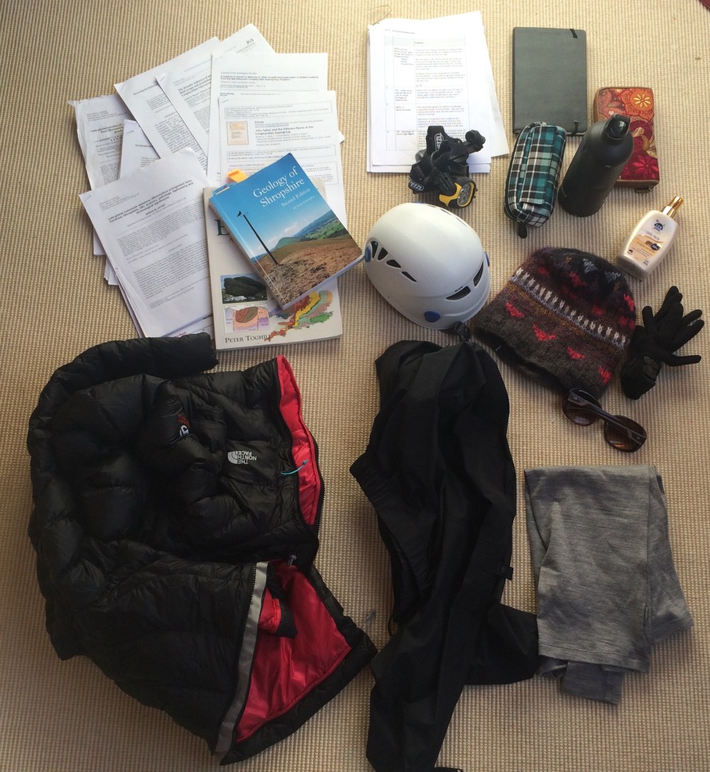
Typical contents of my Walking Through Time back pack!

Shockingly, some of you think I had a back pack stuffed with newspaper! I have heard tales of outdoorsy presenters filling their bags with bubblewrap, but my back pack was actually in actual, proper use. We were out all day, and had to walk quite long distances, so had to be prepared in the same way you would on a hike. And anyway, nothing looks more rubbish than an unweighted back pack!

For each episode, my back pack had in it:

  • all weather gear: My woolly hat and gloves, my waterproof trousers, my down jacket, an extra thermal layer, my sunglasses, my factor 50 sunscreen
  • My climbing helmet and head torch: you never know when you might want to look at an unstable cliff face, head into a cave, or furtle around in the dark corners of museums.
  • Geology textbooks, for on the hoof fact-checking
  • quite a few Scientific papers (ditto)
  • Script & call sheet (the ‘call sheet’ has all the important info about location addresses, phone numbers and timetables for filming)
  • notebook and pencil case
  • my wallet and phone (not that there much phone signal)
  • walky-talky, to communicate with Team Rosalind to see how she was and find out when she would be coming by for a feed
  • water bottle, and –if we were away form civilisation all day– my lunch
  • and between shots, I also carried whatever camera kit and extra water and food for the crew that I could manage. That’s why there are a few unsightly moments where my bag looks rather poorly packed — I had just whipped out the kit and not rearranged my bag so it was weighted properly!

Where was Scotland 1.2 billion years ago? And what was it like?

screen-shot-2016-09-28-at-11-04-07

From Stewart, A.D. (2002(. The Later Proterozoic Torridonian Rocks of Scotland: Their Sedimentology, Geochemistry and Origin

The best person to turn to for this answer has to be the father of Torridonian geology, Sandy Stewart. The figure, borrowed from his book, shows the location of what is now Scotland at 1.2 billion (when the Stac Fada member was laid down, forcing its way between the sands of the ‘Stoer Group’ of Torridonian sandstones), and then at 1 billion years ago (which is when the bulk of the Torridonian sandstones — the ones that mountains like Stac Pollaidh are made of — began to be deposited).

1.2 billion years ago, the Assynt region of Scotland was on the edge of the ancient continent known as Laurentia, at a latitude of around 25ºN. The sea was maybe a few hundred kilometres away. The climate was probably equivalent to a subtropical steppe — nice and warm, not too wet but not too dry either! The earlier Stoer deposits were lain down by rivers, so imagine a huge river system perhaps, flowing towards the west. But, and this is, key — there is no terrestrial life. No plants fringing these rivers, and certainly no animals swimming with them, or moving beside them. I fact, imagine a river flowing on Mars (but with a subtropical climate!), and you’d be close.

Later on, after the impact (and perhaps because of the impact), the drainage shifted and a lake formed. So tranquil waters in a quiet world, undisturbed by the call of a bird, or the chirrup of an insect, or even by the sound of the wind in the trees. Empty and still.

I think I have found a meteorite, what do I do?

If you have found a possible meteorite (how exciting), the best thing to do is to take it to your local museum and ask them if they can help to confirm your discovery. Or you can ask experts at the Natural History Museum in London by using the online identification forum NaturePlus. You’ll need to take a picture (make sure you include a scale to show its size — a coin or a pen will do, if you don’t have a ruler handy), and also include as much information as you can about where you found it, and when.

Can you identify a rock, or a geological section for me?

I am afraid not — unless you have found an elephant fossil, then I am your woman! As with putative meteorites, the best thing to do is to take it to your local museum and ask them if they can help to identify what you have found. Or join the online identification forum run by the Natural History Museum: NaturePlus. You’ll need to take a picture (make sure you include a scale to show its size — a coin or a pen will do, if you don’t have a ruler handy), and also include as much information as you can about where you found it, and when.

You can also download the new Natural History Museum Fossil Explorer App, which allows you to find out about the geology in your area and also provides guides to most commonly found fossils! This is a useful first step to understanding the rocks and fossils under your feet.

If you want to get into more detail, join the Geologists Association. They run field trips, and have a brilliant magazine. They also produce the brilliant RockWatch magazine for younger members.

Where was that spectacular fishing spot in Assynt?

I couldn’t possibly divulge the location of Stewart’s secret fishing spots 😉 But if you want a guide, he can be contacted here  https://www.facebook.com/assyntflyfishing/

Will there be a DVD of the series?

I am afraid I don’t know. I hope so, as I would like one (and so would my Mum!).